
Donera
Utrusta dig för ditt nästa äventyr:
Som Amazon-partner tjänar denna webbplats provision på kvalificerade köp, utan extra kostnad för dig.
Topografisk karta Sunspot
Klicka på kartan för att visa höjden.
Donera
Utrusta dig för ditt nästa äventyr:
Som Amazon-partner tjänar denna webbplats provision på kvalificerade köp, utan extra kostnad för dig.
Sunspot
Sunspot is an unincorporated community in the Sacramento Mountains in the Lincoln National Forest in Otero County, New Mexico, United States, about 18 miles (29 km) south of Cloudcroft. Its elevation is 9,186 feet (2,800 m). The Sunspot Solar Observatory and Apache Point Observatory are located in Sunspot in the Sacramento Mountains. The site of Sunspot is leased by the National Science Foundation (NSF) from the US Forest Service (USFS), and is operated and maintained by the Association of Universities for Research in Astronomy. The telescope and site are both open to the public, and the visitors center offers guided tours of the site on Saturdays and Sundays. On other days there is a self-guided 1/2 mile trail around the telescope and White Sands overlook.
Donera
Utrusta dig för ditt nästa äventyr:
Som Amazon-partner tjänar denna webbplats provision på kvalificerade köp, utan extra kostnad för dig.
Om denna karta
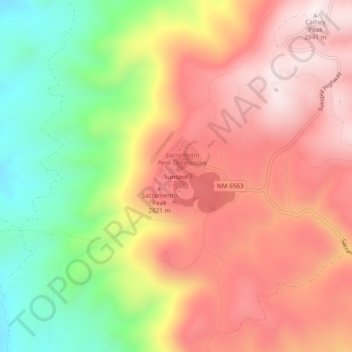
Namn: Topografisk karta Sunspot, höjd, relief.
Plats: Sunspot, Otero County, New Mexico, 88349, United States (32.76921 -105.83857 32.80921 -105.79857)
Medelhöjd: 2 626 m
Minsta höjd: 2 243 m
Maxhöjd: 2 932 m
Donera
Utrusta dig för ditt nästa äventyr:
Som Amazon-partner tjänar denna webbplats provision på kvalificerade köp, utan extra kostnad för dig.
Andra topografiska kartor
Klicka på en karta för att se dess topografi, dess höjd och dess relief.
Alamogordo
United States > New Mexico > Otero County
As of 2010, Alamogordo had a total area of 19.3 square miles (50.0 km2), all of it land. The city is located at an elevation of 4,336 feet (1,322 m) on the western flank of the Sacramento Mountains and on the eastern edge of the Tularosa Basin. It lies within the Rio Grande rift and in the northernmost part of…
Medelhöjd: 1 515 m
Cloudcroft
United States > New Mexico > Otero County
Cloudcroft is a village in Otero County, New Mexico, United States, and is located within the Lincoln National Forest. The population was 674 at the 2010 census. Despite being located in an otherwise arid region, its high elevation (8,676 feet (2,644 m); one of the highest in the U.S.) allows for a mild summer…
Medelhöjd: 2 643 m
La Luz
United States > New Mexico > Otero County
The largest employer in the surrounding area is Holloman Air Force Base. La Luz itself is largely residential and agricultural in land use but a small market is located on the state maintained road that connects the village to Highway 70. La Luz has long been known for the many fruits that are grown in the…
Medelhöjd: 1 487 m
Donera
Utrusta dig för ditt nästa äventyr:
Som Amazon-partner tjänar denna webbplats provision på kvalificerade köp, utan extra kostnad för dig.
Alamogordo
United States > New Mexico > Otero County
As of 2010, Alamogordo had a total area of 19.3 square miles (50.0 km2), all of it land. The city is located at an elevation of 4,336 feet (1,322 m) on the western flank of the Sacramento Mountains and on the eastern edge of the Tularosa Basin. It lies within the Rio Grande rift and in the northernmost part of…
Medelhöjd: 1 427 m
Timberon
United States > New Mexico > Otero County
Timberon is located at 32°37′54″N 105°41′32″W / 32.63167°N 105.69222°W / 32.63167; -105.69222 (32.631675, -105.692254). Timberon is located in a forested valley, known as Sacramento Canyon, on the southern slopes of the Sacramento Mountains. The Sacramento Creek, an intermittent creek,…
Medelhöjd: 2 181 m
White Sands National Park
United States > New Mexico > Otero County
The first US Army exploration of south-central New Mexico was led by a party of topographical engineering officers in 1849. They passed west of the San Andres Mountains and Organ Mountains. A lieutenant was dispatched east across the basin with a scouting party to map a potential military wagon route to the…
Medelhöjd: 1 214 m
Donera
Utrusta dig för ditt nästa äventyr:
Som Amazon-partner tjänar denna webbplats provision på kvalificerade köp, utan extra kostnad för dig.
La Luz
United States > New Mexico > Otero County
The largest employer in the surrounding area is Holloman Air Force Base. La Luz itself is largely residential and agricultural in land use but a small market is located on the state maintained road that connects the village to Highway 70. La Luz has long been known for the many fruits that are grown in the…
Medelhöjd: 1 487 m
Cloudcroft
United States > New Mexico > Otero County
Its high elevation of 8,676 feet (2,644 m) allows for a mild summer, and the forested mountains make it a tourist attraction for the surrounding deserts. Tourism is the primary economy of the village.
Medelhöjd: 2 643 m
Cloudcroft
United States > New Mexico > Otero County
Cloudcroft is a village in Otero County, New Mexico, United States, and is located within the Lincoln National Forest. The population was 674 at the 2010 census. Despite being located in an otherwise arid region, its high elevation (8,676 feet (2,644 m) allows for a mild summer and forested surroundings that…
Medelhöjd: 2 643 m
Donera
Utrusta dig för ditt nästa äventyr:
Som Amazon-partner tjänar denna webbplats provision på kvalificerade köp, utan extra kostnad för dig.
Alamogordo
United States > New Mexico > Otero County
As of 2010, Alamogordo had a total area of 19.3 square miles (50.0 km2), all land. The city is located at an elevation of 4,330 feet (1,320 m) on the western flank of the Sacramento Mountains and on the eastern edge of the Tularosa Basin. It lies within the Rio Grande rift and in the northernmost part of the…
Medelhöjd: 1 427 m