
Donera
Utrusta dig för ditt nästa äventyr:
Som Amazon-partner tjänar denna webbplats provision på kvalificerade köp, utan extra kostnad för dig.
Topografisk karta Plaza Aldea
Klicka på kartan för att visa höjden.
Donera
Utrusta dig för ditt nästa äventyr:
Som Amazon-partner tjänar denna webbplats provision på kvalificerade köp, utan extra kostnad för dig.
Om denna karta
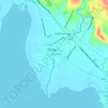
Namn: Topografisk karta Plaza Aldea, höjd, relief.
Plats: Plaza Aldea, Rizal, Calabarzon, 1970, Philippines (14.47681 121.26650 14.51681 121.30650)
Medelhöjd: 12 m
Minsta höjd: -1 m
Maxhöjd: 125 m
Donera
Utrusta dig för ditt nästa äventyr:
Som Amazon-partner tjänar denna webbplats provision på kvalificerade köp, utan extra kostnad för dig.
Andra topografiska kartor
Klicka på en karta för att se dess topografi, dess höjd och dess relief.
Antipolo
Its higher elevation than that of Metro Manila affords it a scenic view of the metropolitan area, especially at night. Its locally grown mangoes and cashews are popular among tourists, as well as suman – a local delicacy made out of glutinous rice. The Hinulugang Taktak National Park, which was once a…
Medelhöjd: 157 m
Montalban
Rodriguez is generally very rough in topography, with 83% of its total land area composed of upland areas, hills and mountain ranges. The remaining 17% low-lying terrain and rolling lands are found at the south-western portion of the municipality, along with the northern portions of the Municipality of San…
Medelhöjd: 230 m
Donera
Utrusta dig för ditt nästa äventyr:
Som Amazon-partner tjänar denna webbplats provision på kvalificerade köp, utan extra kostnad för dig.
Taytay
The shape of Taytay is rectangular – trapezoidal with gently hilly rolling terrain on its eastern side while relatively flat on its south-western side, including the poblacion. The municipality's highest elevation ranges from 200 to 255 meters which is situated along the inner north-eastern hills of Barangay…
Medelhöjd: 37 m
Donera
Utrusta dig för ditt nästa äventyr:
Som Amazon-partner tjänar denna webbplats provision på kvalificerade köp, utan extra kostnad för dig.
San Mateo
The main source of the municipality's water supply are deep wells, pump wells (operated by Manila Water), open wells, springs and other ground water resources. Some of the elevated parts of the municipality are under watershed protected areas since the topography is characterized by rolling to mountainous…
Medelhöjd: 86 m
Donera
Utrusta dig för ditt nästa äventyr:
Som Amazon-partner tjänar denna webbplats provision på kvalificerade köp, utan extra kostnad för dig.
Donera
Utrusta dig för ditt nästa äventyr:
Som Amazon-partner tjänar denna webbplats provision på kvalificerade köp, utan extra kostnad för dig.
Donera
Utrusta dig för ditt nästa äventyr:
Som Amazon-partner tjänar denna webbplats provision på kvalificerade köp, utan extra kostnad för dig.
Donera
Utrusta dig för ditt nästa äventyr:
Som Amazon-partner tjänar denna webbplats provision på kvalificerade köp, utan extra kostnad för dig.
Donera
Utrusta dig för ditt nästa äventyr:
Som Amazon-partner tjänar denna webbplats provision på kvalificerade köp, utan extra kostnad för dig.
Donera
Utrusta dig för ditt nästa äventyr:
Som Amazon-partner tjänar denna webbplats provision på kvalificerade köp, utan extra kostnad för dig.
Donera
Utrusta dig för ditt nästa äventyr:
Som Amazon-partner tjänar denna webbplats provision på kvalificerade köp, utan extra kostnad för dig.
Antipolo
Its higher elevation than that of Metro Manila affords it a scenic view of the metropolitan area, especially at night. Its locally grown mangoes and cashews are popular among tourists, as well as suman – a local delicacy made out of glutinous rice. The Hinulugang Taktak National Park, which was once a…
Medelhöjd: 157 m
Donera
Utrusta dig för ditt nästa äventyr:
Som Amazon-partner tjänar denna webbplats provision på kvalificerade köp, utan extra kostnad för dig.
Donera
Utrusta dig för ditt nästa äventyr:
Som Amazon-partner tjänar denna webbplats provision på kvalificerade köp, utan extra kostnad för dig.
Antipolo
Its higher elevation than that of Metro Manila affords it a scenic view of the metropolitan area, especially at night. Its locally grown mangoes and cashews are popular among tourists, as well as suman – a local delicacy made out of glutinous rice. The Hinulugang Taktak National Park, which was once a…
Medelhöjd: 157 m
Donera
Utrusta dig för ditt nästa äventyr:
Som Amazon-partner tjänar denna webbplats provision på kvalificerade köp, utan extra kostnad för dig.
Muzon
Philippines > Rizal > Taytay
The shape of Taytay is rectangular – trapezoidal with gently hilly rolling terrain on its eastern side while relatively flat on its south-western side, including the poblacion. The municipality's highest elevation ranges from 200 to 255 meters which is situated along the inner north-eastern hills of Barangay…
Medelhöjd: 28 m
Donera
Utrusta dig för ditt nästa äventyr:
Som Amazon-partner tjänar denna webbplats provision på kvalificerade köp, utan extra kostnad för dig.
San Mateo
The main source of the municipality's water supply are deep wells, pump wells (operated by Manila Water), open wells, springs and other ground water resources. Some of the elevated parts of the municipality are under watershed protected areas since the topography is characterized by rolling to mountainous…
Medelhöjd: 86 m
Donera
Utrusta dig för ditt nästa äventyr:
Som Amazon-partner tjänar denna webbplats provision på kvalificerade köp, utan extra kostnad för dig.
Montalban
Rodriguez is generally very rough in topography, with 83% of its total land area composed of upland areas, hills and mountain ranges. The remaining 17% low-lying terrain and rolling lands are found at the south-western portion of the municipality, along with the northern portions of the Municipality of San…
Medelhöjd: 230 m
Donera
Utrusta dig för ditt nästa äventyr:
Som Amazon-partner tjänar denna webbplats provision på kvalificerade köp, utan extra kostnad för dig.
Donera
Utrusta dig för ditt nästa äventyr:
Som Amazon-partner tjänar denna webbplats provision på kvalificerade köp, utan extra kostnad för dig.
San Mateo
The main source of the municipality's water supply are deep wells, pump wells (operated by Manila Water), open wells, springs and other ground water resources. Some of the elevated parts of the municipality are under watershed protected areas since the topography is characterized by rolling to mountainous…
Medelhöjd: 86 m
Antipolo
Its higher elevation than that of Metro Manila affords it a scenic view of the metropolitan area, especially at night. Its locally grown mangoes and cashews are popular among tourists, as well as suman – a local delicacy made out of glutinous rice. The Hinulugang Taktak National Park, which was once a…
Medelhöjd: 157 m
Donera
Utrusta dig för ditt nästa äventyr:
Som Amazon-partner tjänar denna webbplats provision på kvalificerade köp, utan extra kostnad för dig.
San Mateo
The main source of the municipality's water supply are deep wells, pump wells (operated by Manila Water), open wells, springs and other ground water resources. Some of the elevated parts of the municipality are under watershed protected areas since the topography is characterized by rolling to mountainous…
Medelhöjd: 86 m
Donera
Utrusta dig för ditt nästa äventyr:
Som Amazon-partner tjänar denna webbplats provision på kvalificerade köp, utan extra kostnad för dig.
Donera
Utrusta dig för ditt nästa äventyr:
Som Amazon-partner tjänar denna webbplats provision på kvalificerade köp, utan extra kostnad för dig.
Antipolo
Its higher elevation than that of Metro Manila affords it a scenic view of the metropolitan area, especially at night. Its locally grown mangoes and cashews are popular among tourists, as well as suman – a local delicacy made out of glutinous rice. The Hinulugang Taktak National Park, which was once a…
Medelhöjd: 157 m
Donera
Utrusta dig för ditt nästa äventyr:
Som Amazon-partner tjänar denna webbplats provision på kvalificerade köp, utan extra kostnad för dig.
Montalban
Rodriguez is generally very rough in topography, with 83% of its total land area composed of upland areas, hills and mountain ranges. The remaining 17% low-lying terrain and rolling lands are found at the south-western portion of the municipality, along with the northern portions of the Municipality of San…
Medelhöjd: 230 m
San Mateo
The main source of the municipality's water supply are deep wells, pump wells (operated by Manila Water), open wells, springs and other ground water resources. Some of the elevated parts of the municipality are under watershed protected areas since the topography is characterized by rolling to mountainous…
Medelhöjd: 86 m
Donera
Utrusta dig för ditt nästa äventyr:
Som Amazon-partner tjänar denna webbplats provision på kvalificerade köp, utan extra kostnad för dig.
Montalban
Rodriguez is generally very rough in topography, with 83% of its total land area composed of upland areas, hills and mountain ranges. The remaining 17% low-lying terrain and rolling lands are found at the south-western portion of the municipality, along with the northern portions of the Municipality of San…
Medelhöjd: 230 m
Donera
Utrusta dig för ditt nästa äventyr:
Som Amazon-partner tjänar denna webbplats provision på kvalificerade köp, utan extra kostnad för dig.
Donera
Utrusta dig för ditt nästa äventyr:
Som Amazon-partner tjänar denna webbplats provision på kvalificerade köp, utan extra kostnad för dig.
Donera
Utrusta dig för ditt nästa äventyr:
Som Amazon-partner tjänar denna webbplats provision på kvalificerade köp, utan extra kostnad för dig.