
Donera
Utrusta dig för ditt nästa äventyr:
Som Amazon-partner tjänar denna webbplats provision på kvalificerade köp, utan extra kostnad för dig.
Topografisk karta Upper Maculan
Klicka på kartan för att visa höjden.
Donera
Utrusta dig för ditt nästa äventyr:
Som Amazon-partner tjänar denna webbplats provision på kvalificerade köp, utan extra kostnad för dig.
Om denna karta
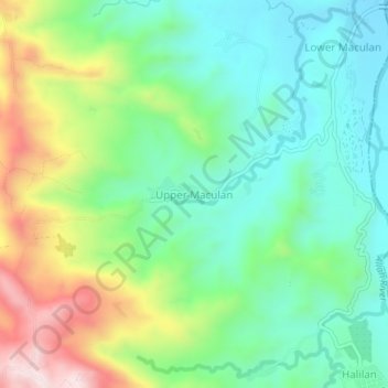
Namn: Topografisk karta Upper Maculan, höjd, relief.
Plats: Upper Maculan, South Cotabato, Soccsksargen, Philippines (6.22014 124.75298 6.26014 124.79298)
Medelhöjd: 499 m
Minsta höjd: 329 m
Maxhöjd: 849 m
Donera
Utrusta dig för ditt nästa äventyr:
Som Amazon-partner tjänar denna webbplats provision på kvalificerade köp, utan extra kostnad för dig.
Andra topografiska kartor
Klicka på en karta för att se dess topografi, dess höjd och dess relief.
Lake Sebu
The placid lake of Lake Sebu can be found in Allah Valley near the municipality of Surallah, South Cotabato. Surrounded by rolling hills and mountains covered with thick rain forest, the lake has an area of 361.124 hectares (892.36 acres), with an elevation of approximately 1,000 metres (3,300 ft).
Medelhöjd: 710 m
Donera
Utrusta dig för ditt nästa äventyr:
Som Amazon-partner tjänar denna webbplats provision på kvalificerade köp, utan extra kostnad för dig.
Koronadal
The city's landscape features a combination of flatlands and gently sloping terrain, with approximately 50.18% of its total land area classified as predominantly flat. It is flanked by the Roxas and Quezon mountain ranges, whose elevations reach between 700 to 800 meters above sea level and gradually slope…
Medelhöjd: 164 m
Donera
Utrusta dig för ditt nästa äventyr:
Som Amazon-partner tjänar denna webbplats provision på kvalificerade köp, utan extra kostnad för dig.
Donera
Utrusta dig för ditt nästa äventyr:
Som Amazon-partner tjänar denna webbplats provision på kvalificerade köp, utan extra kostnad för dig.
Lake Sebu
The placid lake of Lake Sebu can be found in Allah Valley near the municipality of Surallah, South Cotabato. Surrounded by rolling hills and mountains covered with thick rain forest, the lake has an area of 361.124 hectares (892.36 acres), with an elevation of approximately 1,000 metres (3,300 ft).
Medelhöjd: 710 m
Donera
Utrusta dig för ditt nästa äventyr:
Som Amazon-partner tjänar denna webbplats provision på kvalificerade köp, utan extra kostnad för dig.
Donera
Utrusta dig för ditt nästa äventyr:
Som Amazon-partner tjänar denna webbplats provision på kvalificerade köp, utan extra kostnad för dig.
Donera
Utrusta dig för ditt nästa äventyr:
Som Amazon-partner tjänar denna webbplats provision på kvalificerade köp, utan extra kostnad för dig.