

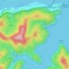
Topografisk karta Northwood
Klicka på kartan för att visa höjden.
Om denna karta

Namn: Topografisk karta Northwood, höjd, relief.
Medelhöjd: 39 m
Minsta höjd: -1 m
Maxhöjd: 106 m
Andra topografiska kartor
Klicka på en karta för att se dess topografi, dess höjd och dess relief.


St Leonards Park
Australia > New South Wales > Sydney > North Sydney
In 2018 it was announced that North Sydney Council would commence an upgrade of the park including improving the war memorial with a reflection pool, restoration of the Tunks Fountain and elevation on a new plinth, new benches, picnic tables, barbecues and drinking fountains, upgrades to lighting, additional…
Medelhöjd: 61 m






Bents Basin State Conservation Area
Australia > New South Wales > Sydney
The park is popular for swimming, kayaking, bushwalking, camping (with 100 tent sites), barbecuing, picnicking and fishing. The park also features walking trails within a bushland and an education centre with a commercial kitchen. Caley's Lookout Track, a walking track within the bushland, leads to Little…
Medelhöjd: 82 m


