
Donera
Utrusta dig för ditt nästa äventyr:
Som Amazon-partner tjänar denna webbplats provision på kvalificerade köp, utan extra kostnad för dig.
Topografisk karta Hernandez
Klicka på kartan för att visa höjden.
Donera
Utrusta dig för ditt nästa äventyr:
Som Amazon-partner tjänar denna webbplats provision på kvalificerade köp, utan extra kostnad för dig.
Om denna karta
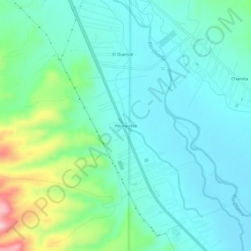
Namn: Topografisk karta Hernandez, höjd, relief.
Medelhöjd: 1 767 m
Minsta höjd: 1 715 m
Maxhöjd: 1 949 m
Donera
Utrusta dig för ditt nästa äventyr:
Som Amazon-partner tjänar denna webbplats provision på kvalificerade köp, utan extra kostnad för dig.
Andra topografiska kartor
Klicka på en karta för att se dess topografi, dess höjd och dess relief.
Espanola
United States > New Mexico > Rio Arriba County
Española lies at an elevation of around 5,595 feet (1,705 m) with much variance. It is in a valley nestled between the Jemez and Sangre de Cristo mountain ranges, and the meeting point of three rivers, the Rio Grande, the Rio Chama, and the Rio Santa Cruz.
Medelhöjd: 1 739 m
Dulce
United States > New Mexico > Rio Arriba County
Dulce is the southernmost urban area with a subarctic humid continental climate in North America (Köppen: Dfc) where summer is mild and short due to high altitude and rigorous winter. Going further south than the Dfb in low altitude and in latitude similar to the southern limit of the Dfa in the center of the…
Medelhöjd: 2 179 m
Donera
Utrusta dig för ditt nästa äventyr:
Som Amazon-partner tjänar denna webbplats provision på kvalificerade köp, utan extra kostnad för dig.
Espanola
United States > New Mexico > Rio Arriba County
Española lies at an elevation of around 5,595 feet (1,705 m) with much variance. It is in a valley nestled between the Jemez and Sangre de Cristo mountain ranges, and the meeting point of three rivers, the Rio Grande, the Rio Chama, and the Rio Santa Cruz.
Medelhöjd: 1 739 m